মূল ফাইল (4,016 × 4,252 পিক্সেল, ফাইলৰ মাত্ৰা: 1.91 MB, MIME প্ৰকাৰ: image/jpeg)

এই ফাইলটো ৱিকিমিডিয়া কমন্সৰ পৰা আমদানি কৰা হৈছে। ফাইল বিৱৰণ পৃষ্ঠাৰ সবিশেষ তথ্য তলত উল্লেখ কৰা হ’ল ।
ৱিকিমিডিয়া কমন্স এটা মুক্ত অনুজ্ঞাপত্ৰ মিডিয়াৰ ভঁৰাল। আপুনিও ইচ্ছা কৰিলে এই প্ৰকল্পত সহায় কৰিব পাৰে

সাৰাংশ

Druidic Calendar

বিৱৰণ
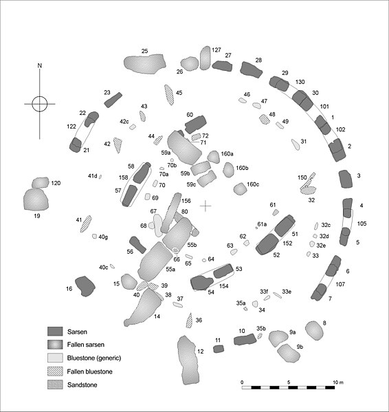
English: Plan of the central Stone Structure at Stonehenge as it survives today. Stone numbers are those conventionally used in the recent literature and following Petrie, F. 1880.

Note that the Term 'Sarsen' used on the key refers to the hard silicified tertiary rock local to the chalkland of the Stonehenge region, sarsen is an exceptionally obdurate form of sandstone: The reference to sandstone on the key is to other ‘non sarsen’ material. The term ‘bluestone’ conveniently, though somewhat controversially, describes a generic group of igneous rock exotic to Salisbury Plain. The major group of bluestones visible today are dolerite - whose province is regarded as south west Wales. A number of other igneous rocks are represented within the arrays. Those interested in the exact make up of the blustone assemblage are referred to Cleal 1995, and Cunliffe and Renfrew 1997.

Cleal, R. M. J., Walker, K. E. & Montague, R., Stonehenge in its landscape (English Heritage, London, 1995)

Cunliffe, B. & Renfrew, C. Science and Stonhenge (Proceedings of the British Academy - 92, Oxford University Press 1997)

Johnson, A. Solving Stonehenge (Thames & Hudson 2008)
তাৰিখ
উৎস Drawn by Author , a computer compilation of data from various surveys.
লেখক Anthony Johnson
অনুমতি
(এই ফাইলৰ পুনঃব্যৱহাৰ)
By Author ©Anthony Johnson 2008

অনুজ্ঞাপত্ৰ

ম‍ই, এই কামৰ স্বত্বাধিকাৰী, ইয়াৰ দ্বাৰা ম‍ই এই কামক তলত বৰ্ননা দিয়া অনুজ্ঞাপত্ৰৰ অধীনত প্ৰকাশ কৰিলো:
GNU head GNU Free Documentation License ৰ চুক্তিসমূহৰ অন্তৰ্গত এই দস্তাবেজ কপি, বিতৰণ আৰু/অথবা সলনি কৰাৰ অনুমতি প্ৰদান কৰা হৈছে, সংস্কৰণ 1.2 অথবা Free Software Foundation দ্বাৰা প্ৰকাশ কৰা পিছৰ যিকোনো সংস্কৰণত; কোনো অপৰিবৰ্তনশীল অংশ, কোনো ফ্ৰন্ট-কভাৰ টেক্সট, আৰু কোনো বেক-কভাৰ টেক্সট নহোৱাকৈ। অনুজ্ঞাৰ এটা কপি GNU Free Documentation License নামৰ অংশত অন্তৰ্ভুক্ত কৰা হৈছে।
w:en:Creative Commons
স্বীকৃতিপ্ৰদান
This file is licensed under the Creative Commons Attribution 3.0 Unported license.
আপুনি স্বাধীনভাৱে:
  • বিতৰণ কৰিব পাৰে – কামটো নকল (কপি), বিতৰণ আৰু প্ৰেৰণ কৰিবলৈ
  • পুনৰ্মিশ্ৰণ কৰিবলৈ – কামটো অভিযোজন কৰিবলৈ
তলত উল্লেখ কৰা চৰ্ত্তসমূহৰ ভিত্তিত:
  • স্বীকৃতিপ্ৰদান – আপুনি প্ৰয়োজনীয় স্বীকৃতি দিয়াৰ লগতে অনুজ্ঞাপত্ৰলৈ লিংক আৰু কোনো সালসলনিৰ ইংগিত দিব লাগিব। আপুনি এয়া উপযুক্ত ধৰণেৰে দিব পাৰে, মাত্ৰ অনুজ্ঞাপত্ৰধাৰীয়ে আপোনাক বা আপোনাৰ কামক মঞ্জুৰী জনোৱাৰ দৰে নিলিখিব।
আপুনি আপোনাৰ পছন্দ অনুসৰি অনুজ্ঞাপত্ৰৰ নিৰ্বাচন কৰিব পাৰে।

কেপ্‌চন

এই ফাইলে কি প্ৰতিনিধিত্ব কৰে তাৰ এটা শাৰীত ব্যাখ্যা কৰক

Items portrayed in this file

depicts ইংৰাজী

copyright status ইংৰাজী

copyrighted ইংৰাজী

inception ইংৰাজী

নৱেম্বৰ 2007

ফাইলৰ ইতিবৃত্ত

ফাইলৰ আগৰ অৱস্থা চাবলৈ সেই তাৰিখ/সময়ত ক্লিক কৰক।

তাৰিখ/সময়ক্ষুদ্ৰ প্ৰতিকৃতিআকাৰসদস্যমন্তব্য
বৰ্তমান14:04, 27 September 200814:04, 27 September 2008ৰ সংস্কৰণৰ ক্ষুদ্ৰ প্ৰতিকৃতি4,016 × 4,252 (1.91 MB)Sitehut~commonswiki{{Information |Description={{en|1=Plan of the central stone structure at Stonehenge as it survives today. Conventional stone numbers shown. A eversion of the plan reproduced in 'Solving Stonehenge' (Thames & Hudson 2008).}} |Source=Drawn by Author , a com

তলত দিয়া পৃষ্ঠাটোৱে এই ফাইলটো ব্যৱহাৰ কৰে:

ফাইলৰ গোলকীয় ব্যৱহাৰ

তলত দিয়া আন ৱিকিসমূহে এই ফাইলটো ব্যৱহাৰ কৰে:

মেটাডেটা

"https://as.wiki.x.io/wiki/চিত্ৰ:Stone_Plan.jpg"ৰ পৰা অনা হৈছে